

REPORTS FROM THE RECORDER & ADVERTISING RATES
The Riddlesdown Recorder
On Line
PLANNING APPLICATIONS
PLANNING ADVICE ON
USEFUL LOCAL INFORMATION & LINKS
Information on Local Healthcare, Leisure,
Transport -
Community Page
(Things to do, join and help with)
ABOUT THE
RIDDLESDOWN
RESIDENTS’ ASSOCIATION
ABOUT RIDDLESDOWN
AND ITS COMMON

ABOUT RIDDLESDOWN
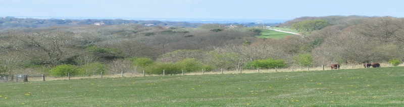
Riddlesdown is a residential and rural area between Purley and Sanderstead and located in the London Borough of Croydon. It has all the advantages of town (with Croydon about 3 miles away, and London just under 30 minutes away by a good train service) and countryside, with Riddlesdown Open Space or ‘Common’, one of its most beautiful attractions, on the doorstep. The ‘Common’ and adjoining land are principally owned by four main land owners; the City of London Corporation, Croydon Council,Tandridge & District Council and the Whitgift Foundation. There are some other private land owners adjoining, which the public have a right of way over. Cattle, sheep and goats can often be seen grazing the pastures.
Interestingly Riddlesdown and/or Sanderstead does not have a public house! Hence the reason the nearest pubs are in Purley, Selsdon, Kenley Hotel Godstone Rd and until 2012, what was the Good Companions in Hamsey Green. However, this only applies to pubs and not off licences (Majestic Sanderstead, Waitrose etc) and private clubs like Purley Downs GC and Purley Bury Social Club. Also alcohol is sold in the convenience shops in Lower Barn Rd and Mitchley Ave.
The reason for this is that some time ago, both the Atwood family (the Lords of the Manor) and the Rector of the church were against drinking and added a restrictive covenant on all land in the area. At the British Library there is a letter from the rector writing to both the parishes of Sanderstead and Warlingham (which lies to the south of the village) calling the latter "sinners" as they visited public houses.
Wikipedia link -
Wikipedia link Sanderstead

Riddlesdown Open Space Countryside Office
General Enquiries -
Emergency telephone number: 01372 279488 (24 hours)
On Site Office (limited opening hours) 020 8660 4625
City of London Commons website Link -
See also various pictures on this website’s Gallery. (‘Riddlesdown then’ and Riddlesdown now’
City of London Commons -
A 2 page map (pdf) of Riddlesdown Open Space is on this link
Source City of London Corporation.
The information below is taken from Croydon Council’s (Parks and Open Spaces) website, (who own the land adjoining the ‘Common’) and is acknowledged with thanks.
Area
37 acres 14.97 Hectares (adjoins a much larger public open space owned by City of London Corporation, Tandridge Council and the Whitgift Foundation).
Facilities
Open fields and downland, horse rides, (City of London car park at the south eastern end of Riddlesdown Road -
History
The main part of Riddlesdown was bought by the City of London in 1833 and the purchase resolved the William Hall lawsuit brought against Squire Byron, Lord of the Manor of Coulsdon.
In 1877 Byron, the Squire of Coulsdon,was taken to the Court of Chancery for encroaching on Common land of the Manor (Land adjoining Riddlesdown chalkpit) The case was brought by William Hall of Little Roke House, which stood off the western corner of Riddlesdown just below the railway, and his brother. As landowners themselves, it would have been of benefit if the land had in fact been enclosed. Apart from its immediate effect ,the case of Hall vs. Byron resulted in a large quantity of records about the local people, customs and land holdings at the time. Judgement was given for the Halls, and an injunction restrained Byron from enclosing common land. Hall’s solicitors then sued him for their costs, amounting to £1,000 as no judgement was given on this item. His total costs in the affair were £3,510. The City of London Corporation provided the final solution by paying £7,000 plus the costs for Byrons freehold and rights of commonage.
The purchase of local land for preservation as open space continued in 1883 when the London Corporation bought the other Coulsdon Commons: Farthing Downs, Coulsdon Common and Kenley Common, to add to the existing Riddlesdown acquisition.
The name ‘Riddlesdown’ was first recorded in 1331 as ‘Ridelesdoune’ and is believed to be mediaeval English ‘riddeleah’ -
The area of land which runs from Honister Heights to Hamsey Green was purchased as Greenbelt land and arrested the spread of housing. Much of the land is leased to a local farmer for hay and arable crops, although rights of way still cross the land. There is a Trig point on the side of the track which runs across the area showing that the point is 525 feet above sea level.
The 1910 Ordnance Survey plan shows a Rifle Range on the downland and also a Markers Hut and Rifle Butts.
Riddlesdown is of Archaeological interest and in 1962 three graves were found and may have been connected with a Saxon Cemetery that was found at the junction of Riddlesdown Road and Mitchley Avenue. Stone Axes have also been found on Riddlesdown and have been dated to new Stone age or the Neolithic.
Further human remains were found in Riddlesdown Road on 14 April 2014, whilst landscapers were excavating a driveway in Riddlesdown Road, on the section leading up to the ‘Common’. On 26 April, police have said the recovered bones are at least 1,200 years old and date between 670 to 775 AD. Expert anthropologist analysis was used to date the bones. No further police investigation is now required.
The forensic report will be passed to English Heritage who have expressed further interest in the discovery as it is known that an ancient Saxon burial site is in the vicinity. The Carpenter family at the address have been informed. The scene has now been closed by the police.
Running underneath Riddlesdown is a tunnel half a mile long which carries the railway line from Riddlesdown Station to Oxted.
Riddlesdown has been designated a Site of Special Scientific interest by the Nature Conservancy Council, scrub and covers the steep south west Chalk slopes and the woodland flora includes an orchid which occurs nowhere else in Greater London. Scrub clearance of the land owned by the London Borough of Croydon had also resulted in the re-
THE FOLLOWING IS TAKEN FROM THE
CORPORATION OF LONDON'S PAMPHLET ON RIDDLESDOWN
(acknowledged with thanks to them)
WELCOME TO RIDDLESDOWN
Riddlesdown is a hillside of meadows and woodland that is open to the public all year round. Over a third of a million people live near to the ‘Common’ -
Explore Riddlesdown any time of the year and you will not be disappointed. In the spring and summer it is alive with a myriad of different birds and insects, and is punctuated with drifts of wild flowers, many rare. On a crisp autumn morning the colours of the changing trees are spectacular, especially the sentinel beeches of the ancient Coombes Wood. With the free-
The wildlife enthusiast will find the ‘Common’ teeming, and rarities abound; the walker can set a steady pace across the Downs for a good few hours; the curious stroller will enter into a land of resplendent views and peace.
RIDDLESDOWN FOR HISTORY
The first use of the name "Ridelsdoune" -
The Corporation of London bought most of the land in 1883 to stop the lord of the manor enclosing it. With the Croydon to Oxted railway line being completed the following year, and the Gardener's Pleasure Resort established in 1892 at the foot of Riddlesdown, Victorian day trippers began flocking to the Downs in their thousands -
Its predominant use was to graze sheep and cattle, and the traditional landscape of the Common has been a lot more open than it is today. Grazing halted in the 1930s and woody scrub immediately crept back across the open areas, apart from where grass was mown around the car park and on the flatter land cut for hay. Since the late 1980s, however, this loss of important grassland has been stopped and the animals are back!
RIDDLESDOWN FOR PEOPLE
Discovering Riddlesdown is easy wherever you are! The Common is criss-
Riddlesdown plays a central part in the lives of local people. For many summers the ‘Common’ has been host to the Riddlesdown Residents' Association's Fun Day. Sadly due to financial constraints with the City of London this has had to stop for the time being.
Join regular guided walks and talks about the Common advertised on notice-
RIDDLESDOWN FOR WILDLIFE
Riddlesdown is a wildlife haven -
Its chalk bedrock creates soils that support an unusual community of flowers and grasses. In the meadows, resplendent common spotted, pyramidal and rare bee orchids can be found alongside downland herbs such as perforated St.John's wort, marjoram and salad burnet. Feeding on the anthills are green woodpeckers.
Woodland birds, such as nuthatch and tree creeper, live amongst an impressive range of trees and shrubs. The site is renowned for its population of yew trees, the uncommon spindle, and the tiny, but nationally rare juniper -
During summer, keepers regularly spot over twenty species of butterfly, from the easily distinguished red admirals, speckled woods and meadow browns, to the less obvious ringlets, brown argus, green veined whites and Essex skippers. If you're lucky you might catch sight of the nationally rare chalkhill blues.
Deep in the heart of the woodland areas, the rare dormouse lives out its nocturnal and secret life eating hazelnuts and blackberries and sleeping in nests of stripped wild clematis.
The following is an article by Andrew Scott of the Corporation of London, written for the April 2005 Riddlesdown Recorder:
THE ROMAN ROAD ON RIDDLESDOWN
Archaeologists believe that the bridleway known as Riddlesdown Road over Riddlesdown formed part of a Roman road linking London to Portslade, near Brighton, on the south coast. The road was probably built about 150AD and was one of two main routes linking the prosperous corn-
The exact course of the full length of the Roman road was deduced from a mixture of finding actual remains at certain points including their alignments, i.e. the direction surviving fragments pointed, as well as inferences from straight lengths of modern road and significant place names. Ivan Margary published his account of the road’s course in Surrey Archaeological Collections in 1937 on which this article is based.
The nearest section of Roman road to Riddlesdown that has been excavated lies about half a mile north of Caterham station near Tillingdown Hill. Here it was found to be about 25 feet wide and layered with 12 inches of flints. It’s thought that rainfall here was higher in the Roman period than it is today and therefore the winter flooding of the Bourne would have been a real obstacle to road builders. In fact it wasn’t until 1790 that the Godstone Road was built along its present course in the valley bottom.
So the Romans avoided the wet valley by building their road over Riddlesdown. They probably didn’t metal their road, relying on drainage ditches to keep its surface dry. No physical traces of the Roman road have been found here (a possible investigation for the future?). Based on the alignment of Riddlesdown Road over the highest part of Riddlesdown and the crossing in Purley, Margary was convinced that the original Roman road then continued northwards along the line of the public footpath which continues as Downs Court Road.
Saxon graves were discovered when houses were built along Riddlesdown Road in 1927 and when a trench was dug in their gardens in 1962. Their alignment suggests that a route across Riddlesdown was still in use some 1400 years ago. Certainly the road over Riddlesdown was the main route for traffic to Brighton and Lewes in the eighteenth century. Horses were changed at the coaching inn at the foot of the steep climb from the Godstone Road on their way to London. This inn is known today as the ‘Rose and Crown’, but when it was built in 1743 it was known as the ‘Rose’ (Editor Note 2011: the pub has now been demolished and the site is now two blocks of flats).
Although the construction of the Godstone Road marked its decline as an important road for traffic, motor vehicles continued to use it as late as the 1970s, when it became maintained as a bridleway.
Introducing London’s Newest National Nature Reserve -
The extract below is taken from the City of London’s Newsletter July 2019
“We are thrilled to announce that the Coulsdon Commons have been declared part of a new National Nature Reserve; the South London Downs National Nature Reserve. National Nature Reserves are recognised for having nationally important habitats or species and bring greater levels of protection to conserve landscapes. The NNR will be the second biggest in London, joining Richmond Park and Ruislip Woods, and will bring together the 417 hectares of land managed by City of London and London Borough of Croydon to create a landscape both rich in nature and where people can engage with the natural world.”
A map of the South London Downs National Nature Reserve
A map of the South London Downs National Nature Reserve showing land ownership.
The above maps are published and acknowledged with thanks to the City of London Corporation and Croydon Council.