SHORT WALKS AND MINOR EXCURSIONS WITHIN A FEW MILES OF RIDDLESDOWN
Updated 30/12/24
Do you ever wonder where to go for a walk around Riddlesdown ? This page lists a few of the many places to try. We need your recommendations to keep this page going. Please e-mail the RRA RiddlesdownResidents@gmail.com with any local places that you would suggest to be added, or any errors with links not working.
WALKS ON SOME OF THE NEARBY CITY OF LONDON COMMONS
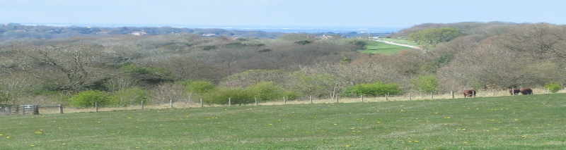
RIDDLESDOWN - It takes about 40 minutes for a very leisurely walk across Riddlesdown Common from the Carpark (note; parking charges apply) at the end of Riddlesdown Road to Hamsey Green by Tithepit Shaw Lane. Or alternatively walk past the quarry and down to Whyteleafe, and/or then walk then cross the A22 (Godstone Rd) and climb up to Kenley Common/Air Field. Or walk through Mitchley Woods and other wooded areas nearby to footpath exits to Limpsfield Rd, Holmwood Ave or Mitchley Hill.
A 2 page map (pdf) of Riddlesdown Open Space is on this link
Source City of London Corporation.
Information from City of London Corporation - Riddlesdown; Link
COULSDON COMMON - Car Park in Fox Lane - Wooded area.
Further information from City of London Corporation; Link
FARTHING DOWNS/HAPPY VALLEY/NEW HILL, DITCHES LANE, COULSDON - Large open and wooded areas with walks. Carpark - note parking charges apply. Further information from City of London Corporation; Link
KENLEY COMMON/AIRFIELD - Plenty of wooded and open areas. Sometimes the gliders are up from Kenley Aerodrome. The Wattenden Arms nearby in Old Lodge Lane. Kenley Common surrounds Kenley Airfield owned by the MOD and used by the RAF for glider training. The Common holds seven World War II fighter pens, which together are a Scheduled Monument, however it is the completeness of the airfield, the history of which is closely bound up with Kenley Common, that make this a site of national historical significance. Street parking on Hayes Lane
Further information from City of London Corporation; Link
SPRING PARK - KENT GATE WAY, ADDINGTON/WEST WICKHAM (A2022) - is a 20 hectare (50 acre) public open space. Located in the London Borough of Bromley it forms part of a larger area of open countryside within the London green belt that link London with the wider countryside of Surrey and Kent. Limited parking in two small car parks on Kent Gate Way, or in the main car park in Corkscrew Hill.
Further information from City of London Corporation; Link
WEST WICKHAM COMMON, CROYDON ROAD A232 (CONEY HALL)
Further information from City of London Corporation; Link
ASHSTEAD COMMON, SURREY - The Common lies close to junction 9 of the M25. Although there are no public car parks on the site, there is a car park at Ashtead Railway Station. There is also Stew Ponds car park off Christchurch Road, Epsom, which can be used for access to both Ashtead and Epsom Commons.
Further information from City of London Corporation; Link
Follow this link for general information on all of the City of London Commons website, for all Commons in London.
All of the London Borough of Croydon Parks - A to Z of Parks
NEARBY WALKS
DOWNLANDS CIRCULAR WALK - Start from either the Fox Public House, Coulsdon Rd or Farthing Downs Car Park, Ditches Lane Coulsdon. Short walk approx 3 miles (1 - hrs). Long circular walk approx 6 miles (3 - 4 hours) Link
WALKING IN SURREY HILLS - Various Walks Link
COULSDON SOUTH CIRCULAR WALK (10.5 .miles) Link
FARTHING DOWNS & HAPPY VALLEY from Coulsdon South (6 Miles) Link
BANSTEAD WOODS - The large field by Banstead Woods on Holly Lane (B2219), adjacent to Holly Lane car park, Banstead/Chipstead (nearest SATNAV: CR5 3NR). The nearest Rail Station is Chipstead; Good beech woods and open spaces. Banstead Woods (known as Banstead Park Estate) was a deer park in the medieval period sheltering the royal deer (enclosed in 1439). In 1598 Banstead Park was stated to contain about 160 acres. It belonged to the Spencer family in 1841 when the name changed to Banstead Wood. Reigate & Banstead Council website Link
CROHAM HURST, S CROYDON - Hilly, wooded and open area. Link to LB of Croydon website
KINGS WOOD (Sanderstead between Limpsfield Rd and Kingswood Lane) - Pleasant woods with grid of paths. Bluebells in April/May. Link to LB of Croydon
LIMPSFIELD COMMON AND HAREWOODS near Oxted - Large wooded area. Other good areas nearby on escarpment. Link to National Trust website
LLOYD PARK, COOMBE ROAD, CROYDON - Just south east of Croydon town centre, an extensive area of parkland. Link to LB of Croydon website
SELSDON WOOD, OLD FARLEIGH RD - Woods and open areas, bird sanctuary. Link to LB of Croydon website
TOYS HILL AND OUTRIDGE, South east of Westerham Kent - Wooded National Trust area. Fox and Hounds nearby. Link to National Trust website
Surrey Ramblers - www.surreyramblers.org.uk
Croydon Ramblers - http://www.croydonramblers.org.uk/
WESTERHAM - Plenty of walks around the area. Visit Westerham website
Surrey Hills - For further ideas for walks, days out, attractions, villages etc at the
Surrey Hills website
The National Trust
The National Trust in London & South East
Back to Top of Page
Back to Home Page